Geography
Introduction
This document outlines the knowledge, language and concepts that should be taught in Geography. It includes:
Intent
Our Geography draws upon several powerful sources of knowledge. It is our intention that pupils become a little more expert as they progress through the curriculum, accumulating and connecting substantive and disciplinary geographical knowledge.
• Substantive knowledge - this is the subject knowledge and explicit vocabulary used to learn about the content. Common misconceptions are explicitly revealed as non-examples and positioned against known and accurate content as pupils become more expert in their understanding. Misconceptions are challenged carefully and in the context of the substantive and disciplinary knowledge. In our Geography curriculum, it is recommended that misconceptions are not introduced too early, as pupils need to construct a mental model in which to position new knowledge.
• Disciplinary knowledge – this is the use of knowledge and how children become a little more expert as a geographer by Thinking Geographically. We draw upon the work of David Lambert, who references areas teachers can develop tasks for children to ‘Think Geographically’ through Place, Space, Scale, and Interdependence. Peter Jackson and Doreen Massey go further with additional keywords (below) to enable pupils to think hard about comparing and contrasting places, locations, physical and human features, processes, patterns, relationships, connections, environmental challenges, cause, effect and consequences as well as reasoning and explaining change. Jackson and Massey elaborated this further.:
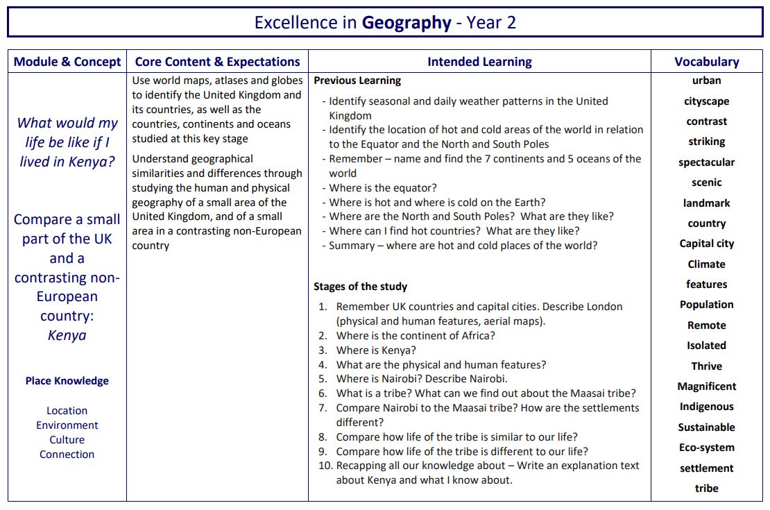
- Proximity and distance - Comparative location of the city of Nairobi or the Yanomami tribe regionally and globally. Give a sense of place and location compared to the images and videos.
- Interactions and inter-dependencies - Trade and relationships with local and global factors. How Nairobi has attempted to model human features on aspects of London and uses its physical locality to encourage tourists to visit.
- Scale - To get a better understanding of locality compared to globality – Zoom in and zoom out.
- Relational perspectives - There is more than one way of living – understanding the culture and ‘the way people do things around here’. For example, how people in Nairobi live with animals, such as lions, making incursion into the city. How the Yanomami tribes take only what they need from the rainforest and live sustainably with little impact
- Geographical imagination - The ways in which people use their local resources to their advantage, such as the Yanomami extracting liquid that stuns fish from the vines in the rainforest.
- New geographical challenges to our ethics - What it means to be a responsible citizen, embracing global dimensions within a local setting – an understanding and respect for ethnicity and diversity through knowing more about other cultures and people. This also gets us thinking about our ethical consumer habits and choices made about sustainability and environmental impact. An example of this could be considering the products we buy that have negatively affected the rainforests or are causing increased pollution.
- Regional inequality - How Nairobi could appear to be a thriving city through publicity but by zooming in and looking more closely how poverty and slums are ever present within the setting of the city and wider communities.
- Uneven development - In a primary school setting, this could be studied as how some areas are unevenly developed and invested in, whilst others are neglected.
The features of thinking geographically in our Geography Curriculum are:
Place and Space Scale and Connection Physical and human geography Environment and sustainability Culture and diversity
• Geographical analysis is developed through selecting, organising and integrating knowledge through reasoning and making sense of the content in response to structured questions and well-designed tasks that cause children to think hard as geographers.
• Substantive concepts are the big ideas, and the golden threads, that run through a coherent and cohesive geography curriculum. The substantive concepts that we develop through our Geography curriculum are:
Locational knowledge Place knowledge Human and physical geography Geographical skills and fieldwork
Our Geography curriculum is built around the principles of cumulative knowledge focusing on spaces, places, scale, human and physical processes with an emphasis on how content is connected and relational knowledge acquired. An example of this is the identification of continents, such as Europe, and its relationship to the location of the UK.
Geography equips pupils to become ‘more expert’ with each study and grow an ever broadening and coherent mental model of the subject. This guards against superficial, disconnected and fragmented geographical knowledge. Specific and associated geographical vocabulary is planned sequentially and cumulatively from Y1 to Y6. High frequency, multiple meaning words (tier 2) are taught and help make sense of subject specific words (tier 3). Each learning module in geography has a vocabulary module with teacher guidance, tasks and resources.
Geography is planned so that the retention of knowledge is much more than just ‘in the moment knowledge’. The cumulative nature of the curriculum is made memorable by the implementation of Bjork’s desirable difficulties, including retrieval and spaced retrieval practice, word building and deliberate practice tasks. This powerful interrelationship between structure and research-led practice is designed to increase substantive knowledge and accelerate learning within and between study modules. That means the foundational knowledge of the curriculum is positioned to ease the load on the working memory: new content is connected to prior learning. The effect of this cumulative model supports opportunities for children to associate and connect with places, spaces, scale, people, culture and processes.
Implementation
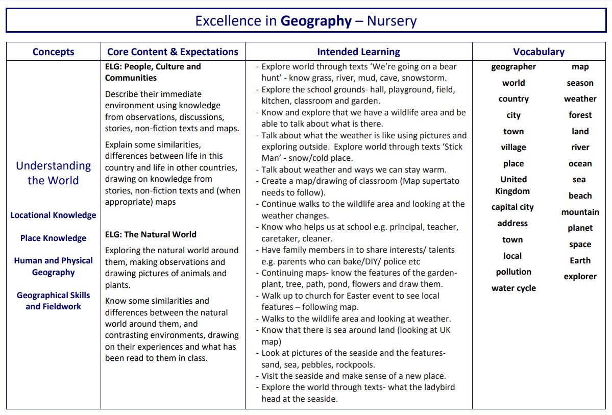
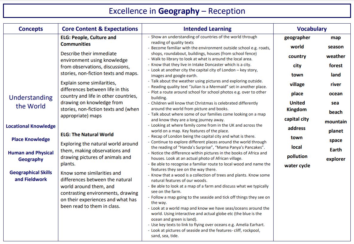
We implement our intent using CUSP Geography. A guiding principle of Geography is that each study draws upon prior learning. For example, in the EYFS, pupils may learn about People, Culture and Communities or The Natural World through daily activities and exploring their locality and immediate environment. This is revisited and positioned so that new and potentially abstract content in Year 1 can be put into a known location and make it easier to cognitively process. Pupils in EYFS explore globes and world locations through their curiosity corners, making links to where animals live. This substantive knowledge is used to remember and position the locations of continents and oceans, with more sophisticated knowledge. High volume and deliberate practice is essential for pupils to remember and retrieve substantive knowledge and use their disciplinary knowledge to explain and articulate what they know. This means pupils make conscious connections and think hard, using what they know.
Learning Sequences
We organise intended learning into modules or units. These group the knowledge, skills and understanding that we want children to remember, do and use. Each module aims to activate and build upon prior learning, including from the early years, to ensure better cognition and retention. The skills required for working in a particular subject are outlined e.g. working scientifically. Close attention is paid to the tier 2 and tier 3 vocabulary to be taught to allow pupils to engage in the required vocabulary. They are deliberately spaced within and across years to introduce and revisit key concepts. This enables staff to deepen pupil understanding and embed learning. Each module is carefully sequenced to enable pupils to purposefully layer learning from previous sessions to facilitate the acquisition and retention of key knowledge.
Lesson Structure
Lessons typically are split into six phases:
• CONNECT This provides an opportunity to connect the lesson to prior learning from a previous module or lesson. Teachers return children’s attention to the previous lesson’s knowledge note/the big idea for the learning module, including key vocabulary. Examples of thinking harder routines include Flick Back 5, Recap questions, Quizzing. Retrieval practice allows all pupils to take time to remember things and activate their memories. Quizzing allows questions to be asked and allows pupils to carry out retrieval practice. Cumulative quizzing, allows for a few questions to be asked each lesson, which are built upon the previous lesson.
• EXPLAIN This is the explicit teaching that needs to take place. Teachers should ensure they are clear what they want children to know and remember. They plan for and explicitly address common misconceptions so they can address these in lessons as they arise. They should be clear about the substantive knowledge and the vocabulary that they want children to understand in the session. This can be developed using key information, facts, and imagesso that explanations are precise.
• EXAMPLE Providing pupils with high-quality examples is essential for learning. Pupils need to see worked examples. My turn, our turn, your turn is a technique that can be used to explicitly teach vocabulary and new concepts. Prepared examples should be carefully planned and need to be evident in teaching. An example in geography could be demonstrating how to label a map, before labelling a map together.
• ATTEMPT Guiding pupil practice allows pupils to rehearse, rephrase and elaborate their learning. Children need the chance to attempt and verbalise their understanding. Children’s own attempts are what help them to secure their understanding. Children need to have time to struggle and understand for themselves. This is not necessarily something that is recorded in books. This phase provides opportunities for teachers to check in with pupils to see who may need more challenge/support/scaffolds and if any misconceptions have arisen that need to be addressed. Extending the previous geography example, pupils could practice labelling a map.
• APPLY This is where pupils would typically begin to record in books. The number of scaffolds may vary.
• CHALLENGE Teachers get the children to interrogate their learning - summarise, explain, compare and contrast. Tools are built into routines to reduce overload and allow for hard thinking. These can be adapted for children based on their individual needs.
SEND Learners
Careers and meaningful opportunities
At Sandringham Primary we provide career links and meaningful opportunities throughout each subject within the curriculum. Our learners benefit from: class discussions, visits from different professionals, visits, webinars and utilising our local expertise.
Impact
In order to identify the impact our curriculum is having on our pupils, we check the extent to which learning has become permanently embedded in children’s long-term memory in addition to looking for excellence in their outcomes. We use four main tools to quality assure the implementation and impact of our curriculum:
• Learning observations help to evaluate subject knowledge, explanations, expectations, opportunities to learn, pupil responses, participation and relationships.
• Professional growth models help to improve staff subject knowledge and evidence informed practice such as retrieval and spaced practice, interleaving and explicit instruction techniques.
• Assessment and achievement articulate the outcomes from tasks and tests, how well the content is understood and what the strengths and limitations are; it informs what to do next.
• Pupil Book Studies help to evaluate curriculum structures, teaching methods, pupil participation and response through a dialogic model.
When undertaking these we ask the following key questions:
Teachers employ a range of strategies both at and after the point of teaching to check the impact of their teaching on the permanence of pupils’ learning. These include: retrieval practice, vocabulary use and application, deliberate practice and rephrasing of taught content, cumulative quizzing within the learning sequence, summarising and explaining the learning question from the sequence, tests and quizzes. Teachers use information from tasks, tests, pupil book studies and other monitoring to support learning by responding to the gap between where pupils are and where they need to be. In lessons, they adapt explanations and examples to address misconceptions and provide additional practice or challenge where required. After lessons or tests, they analyse pupils’ responses to identify shared and individual gaps in learning and misconceptions. Teachers then adjust subsequent planned teaching in response.
We use summative assessment is ‘to provide an accurate shared meaning without becoming the model for every classroom activity’ (Christodolou, 2017). If our curriculum is effective, it will lead to improvements in summative assessments over time. Teacher assessment judgements are against an agreed assessment model (the curriculum). We make summative judgements annually. Teachers record summative judgements on OTrack.
Pupil book study is used as a method to quality assure our curriculum by talking to the children and looking in pupils’ books. We do this after content has been taught to see the extent to which pupils are knowing more, remembering more and able to do more. In preparation, we review the planned content, knowledge and vocabulary, so that conversations with pupils are meaningful and focused on what has been taught. When looking at books, we look at the content and knowledge, teaching sequence and vocabulary. We also consider pupils’ participation and consider the explanations and models used, the tasks the pupils are asked to do, the ability to answer carefully selected questions and retrieve information and the impact of written feedback. We ask careful questions that probe their knowledge, understanding and skills.
The Subject Leader undertakes a range of activities to understand what the curriculum looks like across the school and how well pupils know more, remember more and can do more as a result. In addition to the above tools, they use learning walks, planning reviews and book looks. They use their findings to support teachers to improve how they implement subjects and to make recommendations about the suitability of the intent for their subject. The Subject Leader formally reports on impact of the curriculum annually to the Curriculum Leader, Principal and Governors.
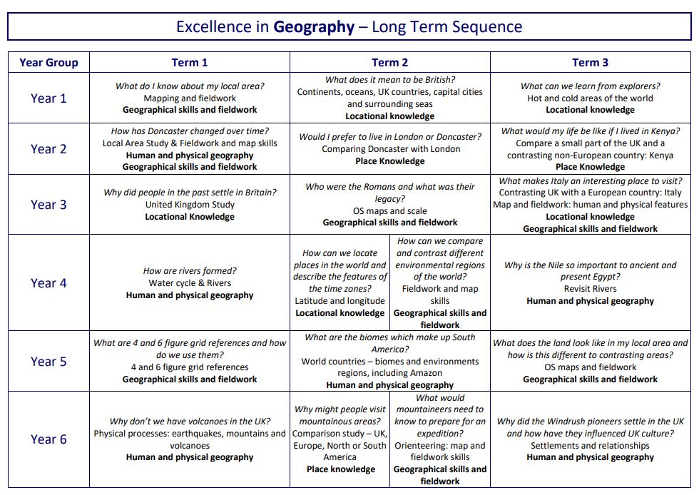
Progression Overview
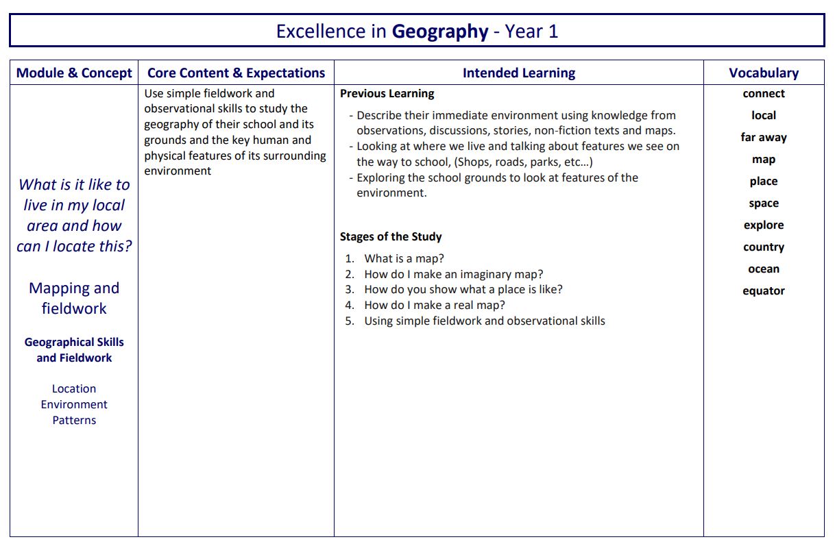
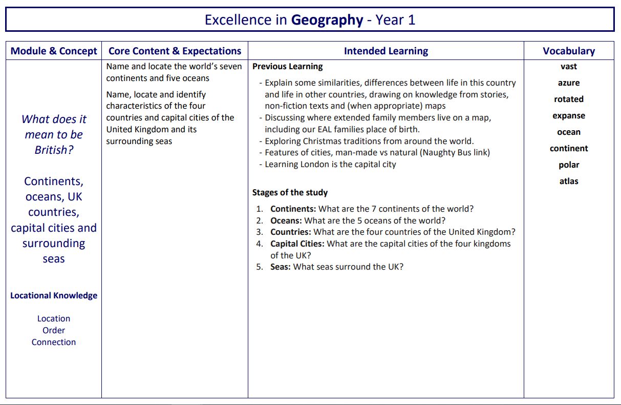
Initially, children study the Orientation of the world through acquiring and making locational sense of the 7 continents and 5 oceans of the world. They extend their knowledge and study the Countries and capital cities of the United Kingdom, along with the oceans and seas that surround us. Further studies support retrieval; children revisit these locations with more complex and sophisticated tasks later in the school year. Enhanced provision in the classroom and use of maps, globes and atlases is essential to form coherent schemata around the big ideas that explain how we know where a place is, and how to locate it. For young children, routes and maps can be made concrete in day-to-day experiences in the safety of their school grounds and classrooms.
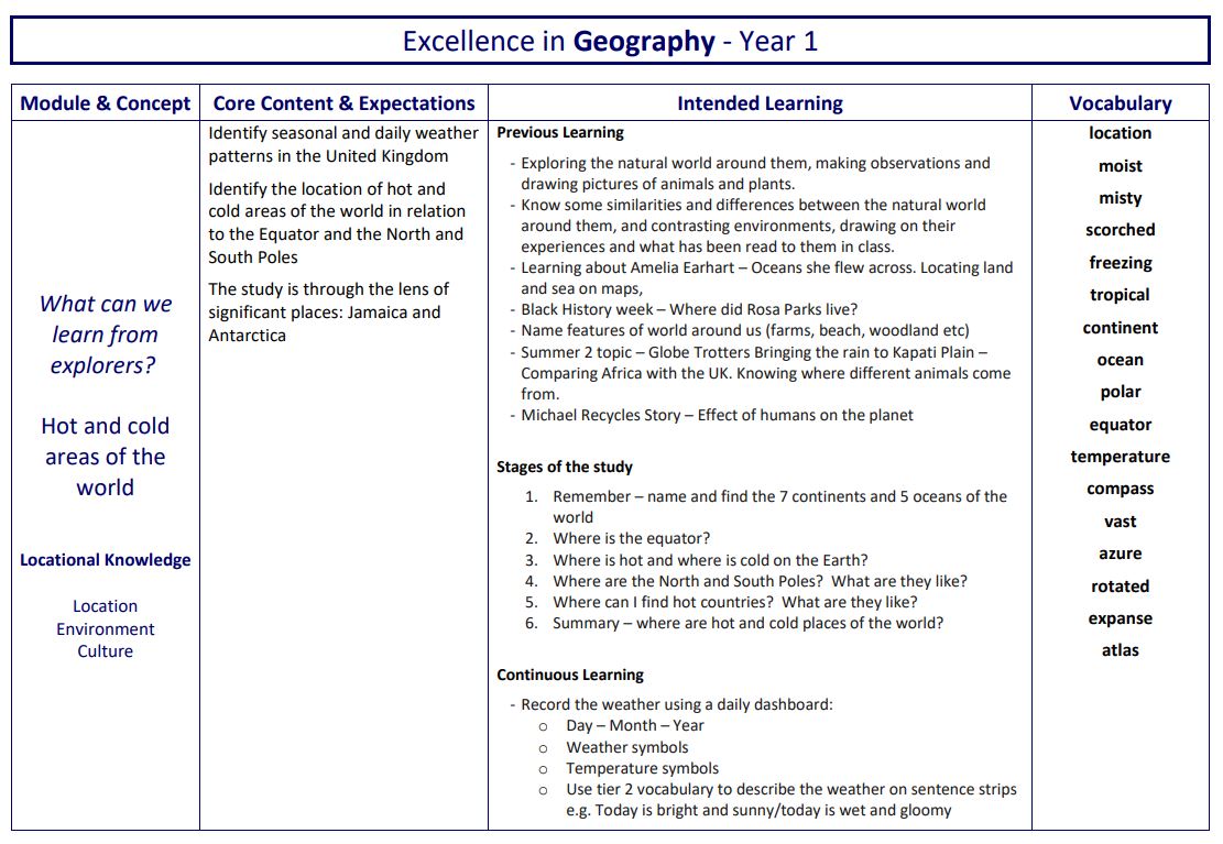
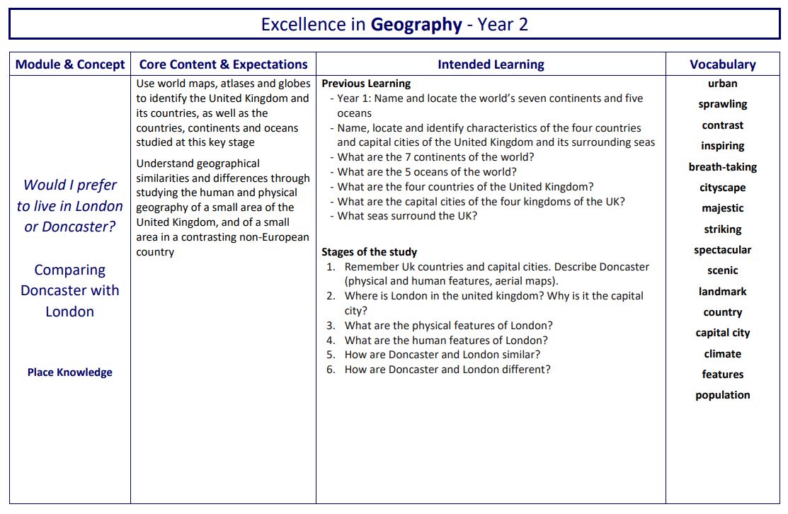
Throughout KS1, pupils enhance their locational knowledge by studying and identifying Human and physical features of places. To deepen this understanding and transfer concepts, pupils study Contrasting locations throughout the world. The location of these areas in the world are deliberately chosen to offer culturally diverse and contrasting places. Pupils study the human and physical features of a non-European location in Africa, such as Nairobi. This is also complemented by a study of an Indigenous tribe Kenya. These two studies also offer rich opportunities to know, compare and contrast different cultures in a different continent using the consistent thread of human and physical features.
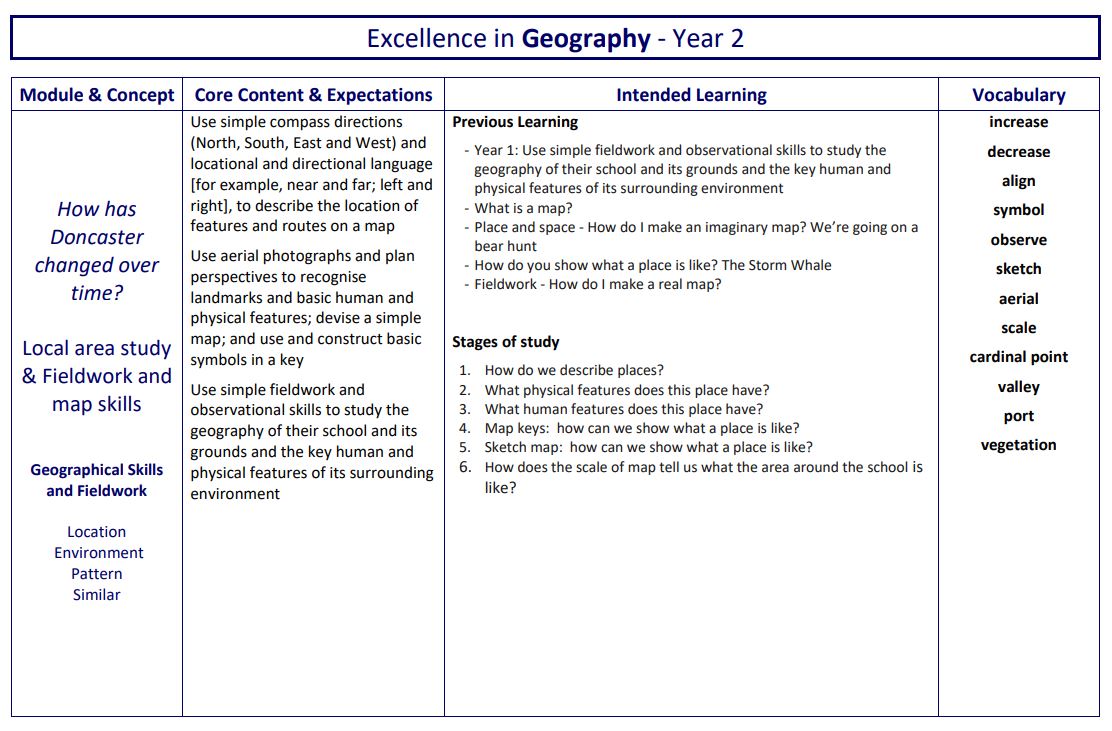
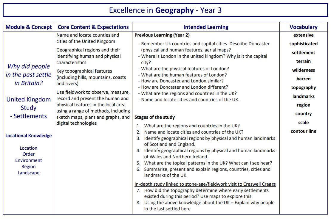
Fieldwork and map skills are further developed with a study of the local area, using cardinal points of a compass. Pupils retrieve and apply knowledge about human and physical features in their local context. OS maps are introduced to pupils in KS1 using Digimap for Schools. Simple keys and features are identified and mapped locally to help begin to understand place, distance and scale. Our Geography curriculum gives pupils the knowledge they need to develop an increasingly sophisticated understanding of place. Pupils study a variety of places – this helps them to connect different geographical concepts and gives them perspectives and opportunities to compare and contrast locations.
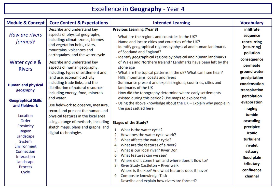
Pupils elaborate and expand their understanding of human and physical features and apply it to the study of Rivers.
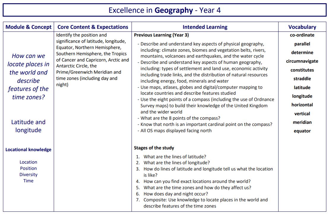
To enable accurate location of places around the globe, pupils study absolute positioning or reference systems through Latitude and longitude. Substantive knowledge is acquired and used to apply their new understanding to mapping and locational skills. An in-depth understanding of latitude and longitude is used by pupils throughout KS2.
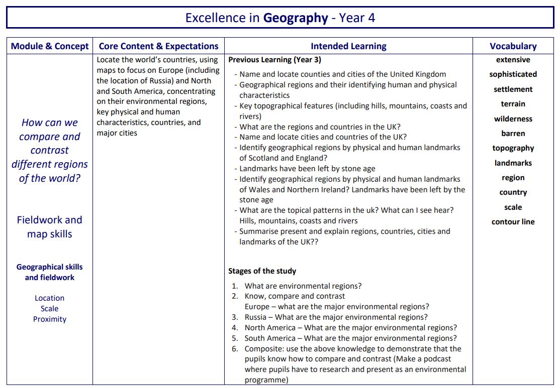
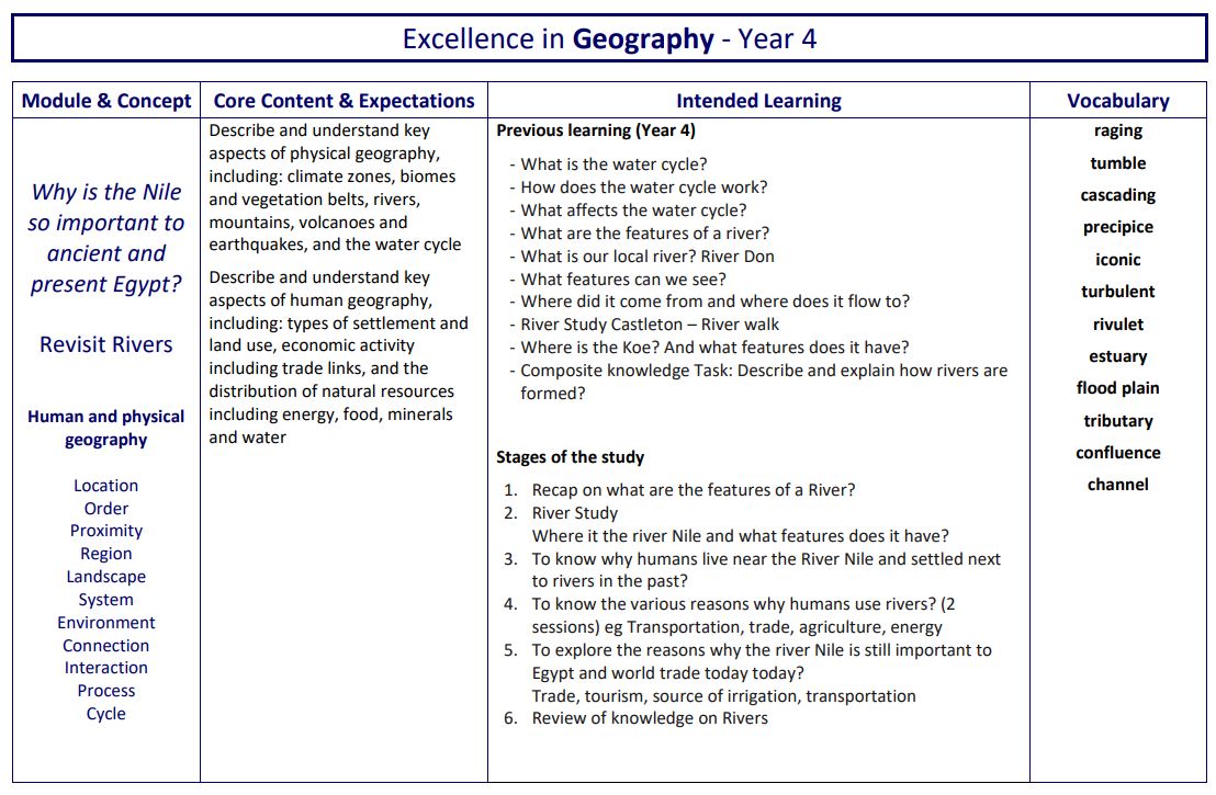
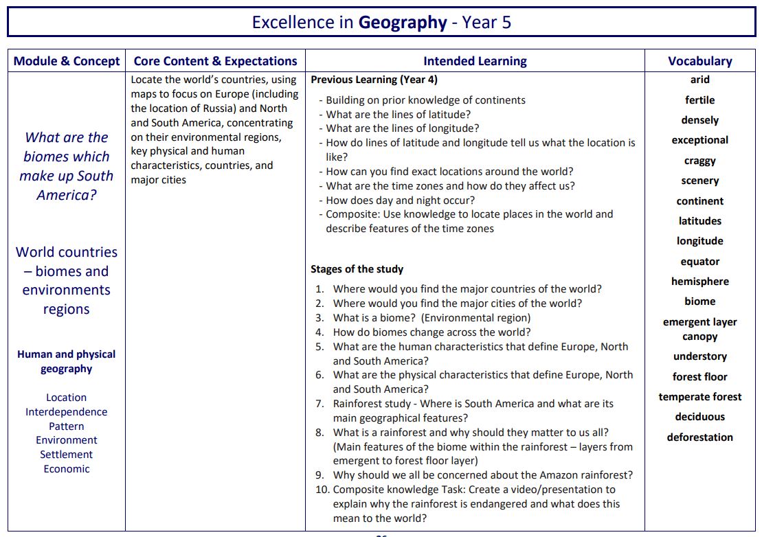
Complementing studies on location and position is the focus on the Water cycle. It offers explanation and reason about physical processes as well as why certain biomes have specific features in specific global locations. Pupils study geographical patterns across the world using latitude of locations to explain why places are like they are. Further river studies revisit substantive knowledge and these are applied to the River Nile and the Amazon River as a precursor for future learning in other subjects. Further fieldwork and map skills are introduced to enrich pupils’ disciplinary knowledge of locations and places. Cultural awareness and diversity are taught specifically within learning modules. Examples include European studies, as well as studies of countries and people in Africa, and North and South America.
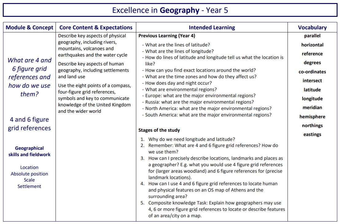
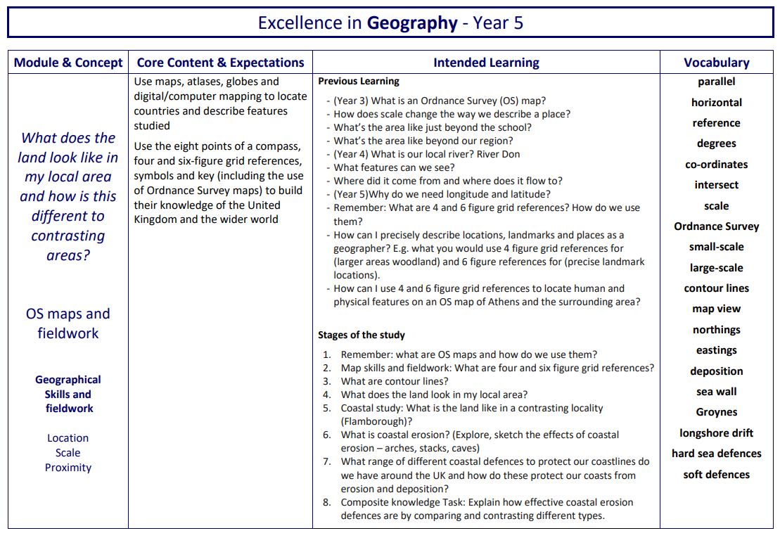
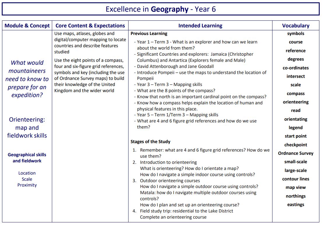
In upper KS2, the study of 4 and 6 figure grid references supports prior learning of reference systems and brings an increased accuracy to mapping and fieldwork skills. Again, this knowledge is designed to be interrelated and connected to the retrieval study of biomes and environmental regions. More advanced mapping skills using OS maps are studied and applied, with pupils using the accumulation of knowledge skilfully to analyse distribution and relationships. Route finding and decoding information through maps offers challenge through increasingly complex orienteering and mapping tasks.
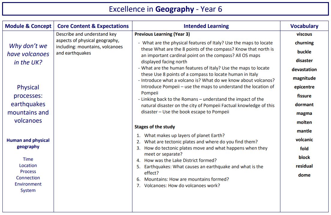
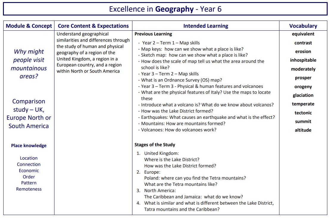
Pupils take part in geographical analysis using patterns and comparison of both human and physical processes as well as the features present in chosen locations. This abstract concept is made concrete through studying and comparing the Lake District, Tatra mountains of Poland and the Blue mountains of Jamaica. Physical processes such as orogeny and glaciation are acquired to explain significant change over long periods of time. The concept of physical process is revisited through a study of Earthquakes, mountains and volcanoes. This depth study allows pupils the opportunity to have a more sophisticated knowledge of physical processes and make connections about how the environment has been shaped, as a result.
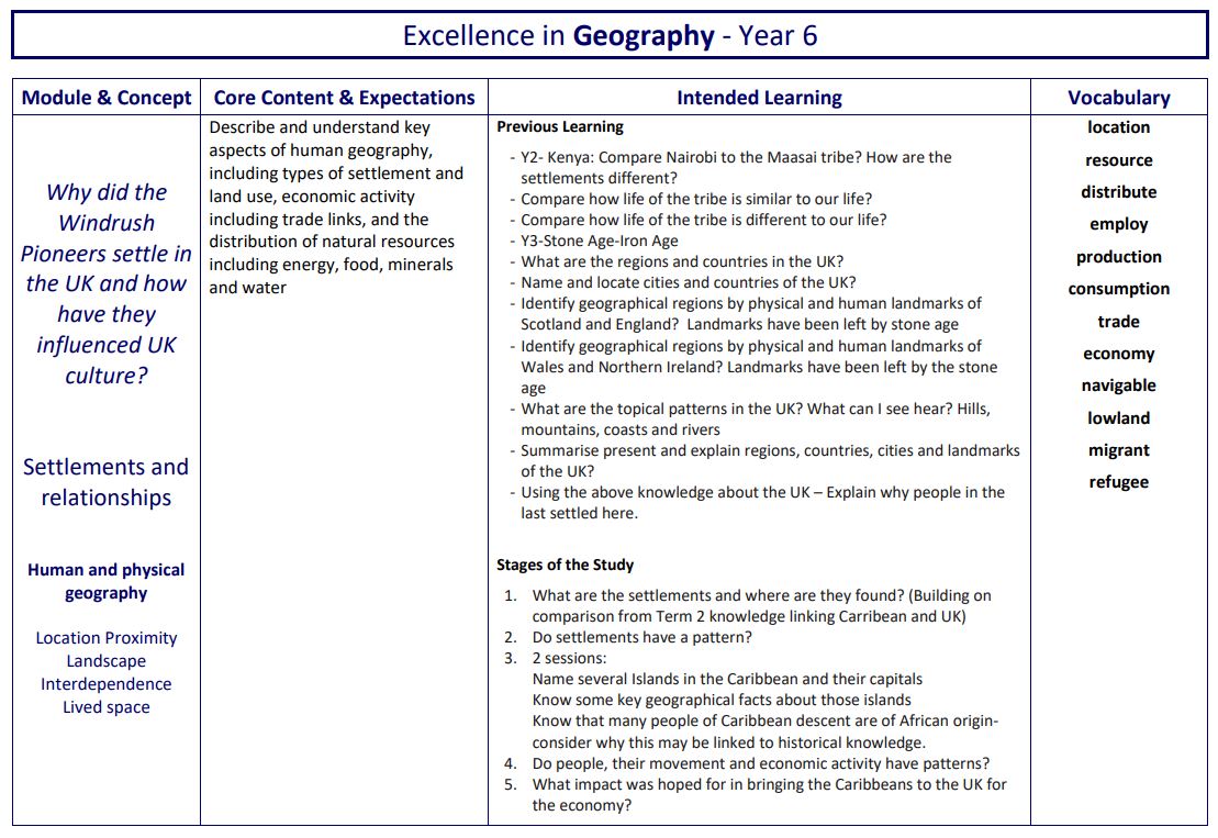
Settlement, trade and economic activities are the focus of a study that draws upon the Windrush generation module in History. This develops an increasing knowledge about migration and the factors that push people away or draw people towards settlements. Within these studies, pupils make relational connections between settlements and physical or human features. Settlements such as ports or major world cities are studied to explain the reasons why certain places are populated and why. Disciplinary knowledge supports pupils to reason and explain the effect of change on a place, drawing on prior substantive knowledge they can retrieve and reuse.